Tuesday, June 11, 2013

Singing Sands Mountain

 We hit the disco last night after roaming the market eating "I'm not sure what on a stick!"  The place was called Baby Face. It was a basement disco packed with twenty-something's..mostly  guys...dancing to 70's disco.

There were three scantly clad young ladies on platforms. The music was pounding and the strove lights mesmerizing. We mixed in on the dance floor, towering over the crowd, and had a grand time. Back to our rooms just after 2am we attempted to get some sleep. Ha-ha!

9am came earlier than usual and we set off on rental bikes for the Singing Sands. Huge sand dunes, some up to 3500 ft surround a natural spring. This spot was teaming with Chinese tourists riding camels and climbing the dunes. It was hot, we were all hung over, and shade was a commodity!

A few hiked the dunes, the smart ones found a tree, some shade, and a beer. Later we biked back into town. I chose to ride around the old city for a few more hours. A few others arranged to visit a local high school and have an English conversation with some students.

For dinner we went back to the night market for Chinese hamburgers and beer. It'll be an early morning as we head for the Great Wall.


Sent from Leopard's iPhone. Read my blog at www.leopard2013.blogspot.com

Monday, June 10, 2013

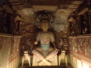
Mogao Grottos

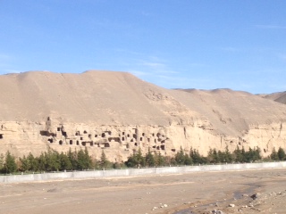
The grottos are 735 caves constructed into the sandstone cliffs beyond Dunhuang and at the vase of the Tibetan Plateau.  They were started in 336AD. We toured the site with a professional, well-spoken guide (refreshing) and then had free time to wander on our own. Our tour included 12 caves, including one with a 150ft Buddha. Amazing.

The colors were original and the statuary unique. I especially liked the entrance guardian standing on demons. There were not a lot of dragons, but plenty of elephants, dogs, and tigers. The buddha statutes were unique in that their was a blending of the early Indian culture with the later reformed Tang, Liang and other Chinese dynasties.  As we were leaving the site a horizontal RSI is appeared over the museum. I'd never seen one before. Enjoy the photo!

We had a free afternoon to explore Dunhuang. A very pretty and beautifully maintained city with grand night markets for food hunting. I wonder what oddities we'll be asked to try tonight!


Sent from Leopard's iPhone. Read my blog at www.leopard2013.blogspot.com

Sunday, June 9, 2013

On the road again...

We left Turpan at 6am for our drive to Dunhuang.  Instead of driving halfway and bush camping for one night, we opted to do the whole drive in one day and add an additional hotel night in the city. Yeah! 

600km of smooth sailing on a beautiful divided super highest lay before us. Mile after mile of rock and sand, black gravel coveref mountains, and sandy bluffs passed by almost endlessly. An occasional windfarm dotted the horizon here and there.  Snow covered mountains rose high to the north-quite a contrast.

Today we left the Tutpan basin and crossed into the southwestern Gobi Desert. One hundred miles north was Mongolia.  By noon we were heading south in the direction of the Tibetean Plateau. So far we have covered about 2800km (1750 miles)-more than half the width of the USA!  And it's pretty much all been desert!

We reached Dunhuang a 6:30pm and settled into our hotel with a view of the Tibetean Plateau. We will spend three days here exploring the oasis and the famous Magao caves.


Sent from Leopard's iPhone. Read my blog at www.leopard2013.blogspot.com

Saturday, June 8, 2013

Ruins of Jiaohe and the Karez irrigation canals

For our full day in Turpan we visited two historic sites.  We passed a lot of markets on the way, the most interesting being the string bean collective. We've been cooking and eating these wonderful beans for a few weeks now and there were millions of them in this street market.  The vineyards were huge and widespread, these being one of the best grape growing regions in the country. 

The ancient city of Jiaohe was built between 700-800 AD. It is a fortified city with a natural river gorge on one side and a manmade canal on the other-both providing excellent protection from invaders. The city was carved out of the soft sedimentary mud and clay and fortified and further developed with mud brick. The city housed 8,000 and was a major commercial stop on the Silk Road. What you can't see from the photos and what we were not allowed to visit was the system of underground tunnels connecting the rooms of many of the buildings. It was hot yet dry. I likened this site to Petra in many regards. The monastary and Buddhist temple is the largest of this period in all of Xianjing province. 

After an ice cream and musk melon break we headed to the Karez exhibit. A "Karez" is an irrigation system of an underground channel, vertical access shafts, an open canal, and a collecting pond. There are over 5,600km of underground channels in the Turpan Basin.  The water source is the Tian Shan mountains. 

We toured the display facility where we were shown how they dug the vertical shafts, the channels, created the slope and collection systems. This process, all done by hand dates back to the 1st century. 

Today roughly 1/3 of the original Karez are in operation and there are no visible signs of conservation. Interesting!


Sent from Leopard's iPhone. Read my blog at www.leopard2013.blogspot.com

Friday, June 7, 2013

Turpan

The oasis of Turpan is located in the Turpan basin, second only to Death Valley, California in elevation below sea level. Returning from Urumqi we were once again in the desert depression. It was 95^ at 2pm and the wind was blowing pretty hard-another dust storm...yippee!

We stopped just before the junction for lunch. Then, guess what?  Our guide missed the turnoff. We were now headed in the wrong direction on a fenced and divided tollway.  Ten kilometers down there was police turnaround. We made an illegal u-turn and were back on track.

Out of the bleak desert sand and Rock sprang a huge, modern oasis city. Where an irrigation canal reached, it was lush and green.

We stopped at the museum for an overview before going to our hotel. It was an amazing museum, beautifully oriented and presented. The mummies were outstanding. With a grand overview of the area, we settled in for a great test bro morrow we tour the ruins, tombs, and irrigation system.

Our hotel, BTW, for the first time on this adventure, was a true "budget" establishment making even the best Motel 6 look and smell like a sultan's palace. Ha-ha!


Sent from Leopard's iPhone. Read my blog at www.leopard2013.blogspot.com

Heavenly Lake (Tian Chi)

Once out of Urumqi our destination was a mere 45km east. Tian Chi (heavenly cloud in mountain) National Park is a major local tourist attraction. The lake is at 7,000 ft and requires a series of transfer busses and then an electric trolley to access. 

We parked Sura, readied nm overnight pack of what we would need for our stay and boarded the transfer busses. Up a steep and winding access road for about 30 minutes brought us to the transfer station where we got on electric trolleys for the last leg. As we arrived at the lake it started to rain and continued until we left the following morning. 

We were met by our yurt hosts and taken by truck to the camp where we settled in for some free time relaxing. In between showers we walked to the lake and toured the temple and monastery. A bus load of brides arrived, along with their grooms in tow, for picture taking. At one point we counted over 100 of them, flouncing around in beautiful gowns and umbrellas. Each followed by a photographer and a stager. Very amusing!

We all shared on yurt, enjoyed dinner of rice and veggies, and slept through the night amidst snoring and raindrops. 

Morning was no different. Yet even with the rain and low hanging clouds it was still quite beautiful and peaceful. We packed up around 9am and headed back to Sura for our six hour drive to Turpan. 

Google "heavenly lake Urumqi" for some amazing photos I wasn't able to take due to the weather. 


Sent from Leopard's iPhone. Read my blog at www.leopard2013.blogspot.com

Getting Out of Urumqi

A hot shower, BBQd chicken on the street, a/c, and beds hard as rocks (really) were followed by a breakfast of rice, seaweed, and coffee-we stayed at a Chinese business hotel. 

Leaving town was no easy task with construction blocking most of the GPS suggested routes. Once again, as has become a daily realization, our local guide is anything but, being absolutely clueless about location and directions. It took two full hours to find our hotel last night.  It's frustrating because the lost time means missing out on things one could have done within our tight schedule. Ok, enough bitching...maybe. 

Urumqi is the capitol of Xianjing province, the largest in China, and home to three major ethnic groups-Uyghur, Kazakh, and Chinese. The Uyghur being the largest accounting for the numerous mosques and the signs still in both Arabic and Chinese. 

Urumqi's 2.5 million people live in a city undergoing huge changes in infrastructure and development.  A new high speed rail system will soon link it with the east. Major freeways will and already weave through old and new skyscrapers. Huge wind farms with hundreds of generators (possibly more) supply new energy to feed the growing need. And theres the nuclear power plant in the centet of the city!  Yikes!  All bing said, it was a pretty city with lots of green space and beautiful people-a blend of eastern and western Asia ethnicities. 

The air was surprisingly clear. The traffic jams were amazing. It took us more than two hours to get out of the city-mostly because we were constantly lost. Frustrating!  Dave and Frenchy have amazing patience!


Sent from Leopard's iPhone. Read my blog at www.leopard2013.blogspot.com

More Desert...Sorta

We slept like rocks and woke up like them too!  80^ at 5:30am!  Stumbling around in the dark we broke camp, stowed our gear and hit the highway. Blazing through the sands we made great time and had put away almost 250km by daylight at 8:30am. It was windy causing a dusty haze. The mountains were mere shadows in the distance and the sun cast eerie rays of light through the din.

Breakfast was in another gravel pit along side the road and next to a drip irrigated orchard. 450km to go. A real bed and shower waiting for us at the other end.

Another 100k and there was cultivated fields as far as you could see in all directions. And, it started to rain. The temperature fell. Wow, a lot of desert land reclaimed for farmland. Good for a hungry nation.

Weaving in and out of desert and farmland we covered another 250 km before lunch.  At a police checkpoint past Korla we saw a Buddhist shrine-several trident shaped poles surrounded and wrapped with hundreds of prayer flags on string. Being a checkpoint, I couldn't take any photos. 

Heading north toward the Mongolia border we crossed a 9,000 ft range and down into the Turpan Basin.  Labeled "the hottest place on Earth," it earned its rep today. Nothing but sand and rock to the horizon. Yet to the east would be the city of Turpan in a couple of days. And it was 104^ on the temperature thingy.

We had noodles at a truck stop along with a self tour of the kitchen. Cute staff!  Good food. Ah-em, not so cute toilets!  Seems to be the norm. Restaurants (and their litchens) are close to clean and the personal facilities aren't. So strange.

Two more hours and another 150km and we arrived in Urumqi. Nice hotel, comfy bed, shower. Ah, now this is overlanding!  Tomorrow-Heavenly Valley!


Sent from Leopard's iPhone. Read my blog at www.leopard2013.blogspot.com
Into The Desert...Again

Today we left Kashgar and began our two-day journey across the Taklamakan Desert, known as the hottest place on earth. It is over 1700 km to the Turpan Basin and oasis. With full water tanks and two new, Chinese approved, propane tanks, we covered almost have of that today. Whew!

Leaving at 6am it was dark for another two hours. Dawn found us traveling along a huge ridge line of the Tian Shan mountains to the north and vast open desert to the south. It seemed almost endless with amazing earthen colors of red, yellow, tan and gray. Alkaline deposits glistened in the morning sun.

China is a building country and just as in Kashgar with skyscrapers and industrial sites under construction, so it was in the desert. We followed a massive highway project for well over 400 miles. Why a four lane super highway is needed to connect a city of 400,000 with the northern unpopulated Chinese desert was a mystery to our guide and intriguing to us.

After 450 km we reached the city of Aksu and its 150,000 people and huge industrial complexes of factories, cement and brick mills, and nuclear power plants.  We had lunch on the outskirts of town at a local cafe and then hit the road for another 300 km. the desert turned from scrub to sand and alkaline flats-the Tian Shan ridge ever present to our right. An oasis would appear occassionally surrounded by acres of irrigated farmland. The temp reached 95^ by 6pm with the sun straight up on the sky. Can't imagine July and August!

The saving factor was a beautifully finished super highway that allowed for fast sailing and a smooth ride!  The rest stops were huge and modern but mostly empty and the shops unoccupied. Obviously something huge is planned for this region.

The further east we went the bigger the factories and surrounding housing got. Where's the water for all if this?  There are no rivers on the map!  And poplar forests sprung from the sand and rock, along with small mud brick towns-no doubt full of laborers.  And then there was still the desert. The heat. Wow!

We drove off the road a few hunted meters to a gravel flat and set up camp. A quick dinner and bed by 10pm ended our day.


Sent from Leopard's iPhone. Read my blog at www.leopard2013.blogspot.com